


Meteorologist Alphonse Mutabazi says that the relatively low margin of error in forecasts issued by Meteo Rwanda—typically not exceeding 40% for 10-day predictions—demonstrates the institution’s strong performance and growing public trust.
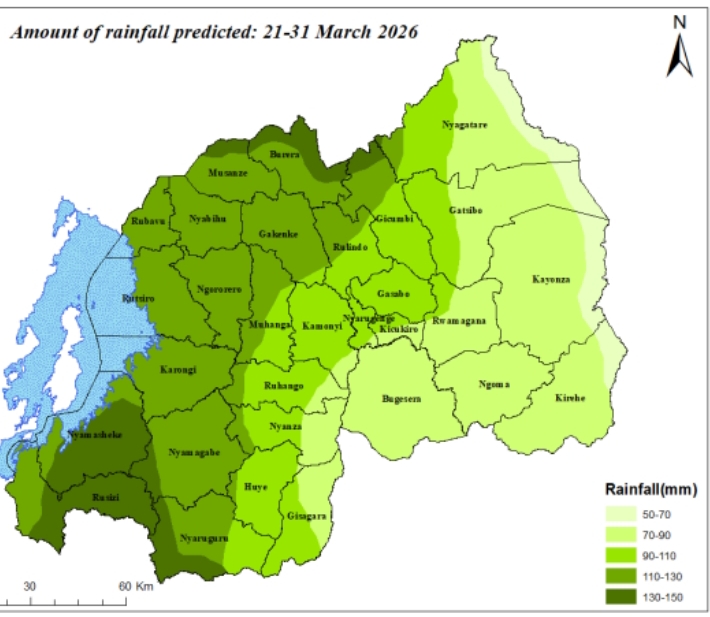
An example can be drawn from a 10-day forecast covering the third dekad of March 2026 (from March 21 to March 31), which projected rainfall between 50mm and 70mm across areas near Rwanda’s eastern border.
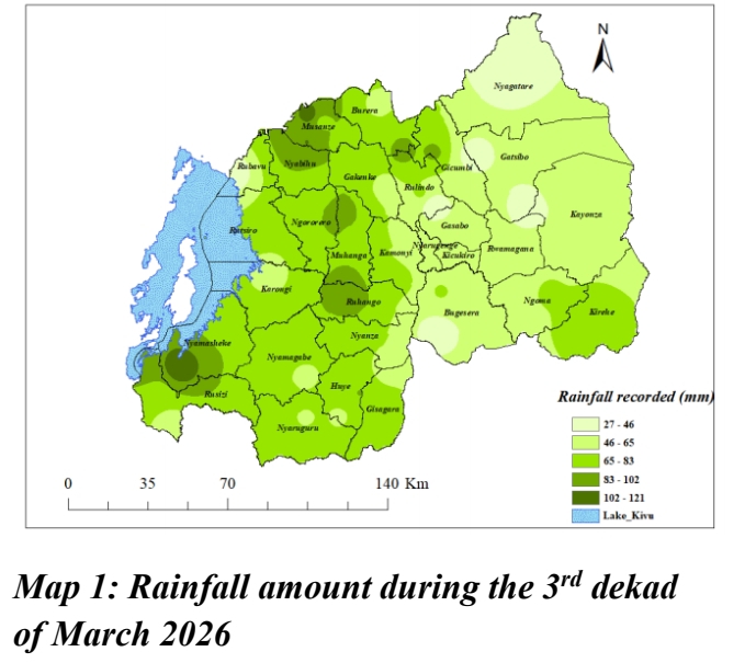
However, a post-analysis conducted by Meteo Rwanda showed that actual rainfall in parts of the region ranged between 27mm and 46mm. This corresponds to an accuracy level of approximately 55% to 65%, with an error margin of around 35%.
In some locations, the margin of error was even lower than 35%, as illustrated by meteorological maps. Still, certain areas recorded significantly less rainfall than initially forecast.
Meanwhile, the science of measurement (Metrology) explains that rainfall is measured in millimeters because when one liter of water spreads evenly over a flat, impermeable surface measuring one square meter, it forms a layer of one millimeter deep.
Mutabazi notes that while most citizens may not fully understand rainfall measurements in millimeters, they are satisfied as long as the predicted rain actually occurs. This practical experience, he says, is what strengthens public confidence in Meteo Rwanda’s forecasts.
Having worked at Meteo Rwanda for nearly a decade, Mutabazi emphasizes that, beyond technical calculations, what matters most is that people are informed of expected rainfall and that it indeed occurs—often significantly during the rainy season. Achieving forecast accuracy between 50% and 60%, he adds, indicates that Meteo Rwanda is meeting its objectives and performing effectively.
He further explains that short-term forecasts—such as hourly or a few hours ahead—are highly reliable, often approaching near 100% effective, since cloud formations already indicate imminent rainfall. However, the longer the forecast period, the higher the uncertainty.
“Forecasts over three hours rarely go wrong. At six hours, accuracy drops slightly. A 24-hour forecast may have about a 10% margin of error, meaning roughly 90% accuracy. But when it comes to monthly or seasonal forecasts, uncertainty becomes much greater,” he says. “For instance, predictions may rely on rainfall patterns from the Atlantic Ocean, yet unexpected influences from the Indian Ocean—previously calm—can disrupt those projections.”
To further reduce forecasting errors, Mutabazi recommends expanding meteorological infrastructure, including installing at least one weather station in every administrative sector across Rwanda. Ideally, each cell should also have rainfall measurement tools, with trained local observers responsible for monitoring, maintaining equipment, and regularly reporting observations.
Where does rain come from?
Rainfall forms when large bodies of water—especially the Indian Ocean, which significantly influences Rwanda’s climate—are heated by the sun over extended periods. This causes water vapor to rise into the atmosphere, where winds carry it inland. As the air cools, the vapor condenses into clouds, which eventually become heavy enough to release rain.
When ocean temperatures are lower and evaporation is limited, fewer rain-bearing clouds form, leading to dry conditions commonly known as La Niña. Conversely, when ocean waters are unusually warm, they produce excessive moisture, resulting in heavy rainfall and sometimes flooding during rainy seasons—a phenomenon known as El Niño.
In most cases, ocean temperatures remain moderate, allowing meteorological agencies to forecast rainfall levels close to seasonal averages.


